The Streets of Downtown Utica's CoLa Neighborhood
Downtown's are roaring back! City urban cores are repopulating, and Downtown Utica is no different. That goes for Utica's CoLa Neighborhood as well! Sadly, CoLa lost too much of it's "street grid" to past Urban Renewal...
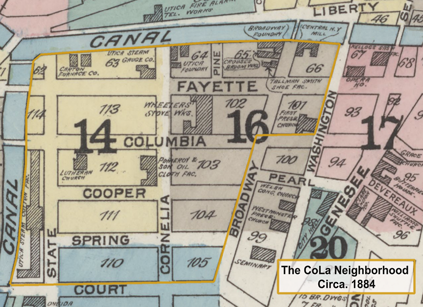
Downtown Utica's & CoLa's Streets, Circa. 1884
Below are names and links to stories behind CoLa's; streets, avenues, lanes, a current day R.O.W., some alleyways, plus one "boulevard" (or is it a street?) stretching across 61 Acres.
Streets like Cooper were named to honor families. For example, Appollos Copper originally owned much of the land in the neighborhood, including the 442 Lafayette Street. Others named to honor early landowners and their families were; Charles, Cornelia and Sayre. We're developing a list of CoLa Companies, past, present and future.
We cover some streets that have been erased due to Urban Renewal, to a time when CoLa use to have 20 different streets! Some erased forever, others have taken on a new identities, others expanded, while still others are posed for revitalization.
The process of revitalization does not have to be overly expensive, BUD is ready to act!
Arterial: Routes 5, 8 & 12
The Arterial as its called is Routes 5, 8 & 12 - This is Utica's newest completed road project. It is built over the former path of the Chenango Canal. Learn more about The Arterial, CoLa's border in the West Edge block group.
Broadway
Broadway - Defining a east side of three block group within CoLa's, Broadway runs from Oriskany Boulevard at the north, towards Court Street where it's southern terminus is located behind the Fort Schuyler Club and at the corner location of Bosnian Islamic Mosque.
Butternut Lane
Butternut Lane - No longer in existance, Butternut Lane is now found beneath the Utica Police Department amd Utica City Courts.
Utica's Canals
Two Canals... The Erie Canal was once Utica's busiest and most productive "street". From the years 1819 to 1920 the canal formed CoLa's northern board. Today the canal path is filled-in, paved over, and called Oriskany Street. Another canal, the Chenango Canal is now the route of Routes 5, 8 & 12 (see Arterial above).
Carton Avenue
Carton Avenue - Or Carton Avenue in CoLa's Central-West block group.
Columbia Street
Columbia Street - This street runs a length of 1,095 feet through the neighborhood, learn more about Columbia Street.
Cooper Street
Cooper Street- This street no longer exists. Prior to Utica's Urban Renewal Project No. 1, Cooper and Spring Street ran through the present day City Hall parcel. Learn more about Cooper Street.
Cornelia Street
Cornelia Street - Like Broadway, Cornelia runs three blocks within neighborhood. Running from Oriskany Street at the north, to CoLa's southern border intersecting at Court Street.
Court Street
Court Street - Positioned at CoLa's southern end, running from the Arterial towards Genesee Street. Within CoLa, Court Street measures 1,576.46 feet (480.50 m) long, but continues under the Arterial and into the Varick Street & Brewery District.
Fayette Street
Fayette Street - See Lafayette Street below, as Fayette was renamed Lafayette Street in .
Kennedy Plaza
Kennedy Plaza - A short drive, Kennedy Plaza, provides access and drop-off to the Kennedy Apartments via Cornelia Street.
Lafayette Street
Lafayette Street - Running east to west, Lafayette Street stretches 2,035 feet throught CoLa.
Madison Lane
Madison Lane - Get to know CoLa's Madison Lane.
Old Whitesboro Road
Old Whitesboro Road - See Court Street.
Oriskany Street
Oriskany Street - Or Oriskany Street, or Boulevard, depending on who you ask. Oriskany Street is CoLa's northern border.
Pine Street
Pine Street - Explore CoLa's Pine Street.
Rome Street
Rome Street - A sign for Rome Street is no longer found in CoLa, however part of it is now Carton Avenue. Prior to the construction of the Chenango Canel, Rome Street may have been the main "Road to Rome" and thus called the "Rome Road".
R.O.W.
R.O.W. - This "right of way" is at at Kennedy Apartments in CoLa's Central- West block group.
Sayer Alley
Sayer Alley - Learn more about CoLa's Sayre Alley.
Spring Street
Spring Street- No longer exists; prior to Utica's Urban Renewal Project No. 1, both Spring Street and Cooper Street ran through the present day City Hall parcel. Learn more about Spring Street.
State Street
State Street - Running north-south, State Street connects CoLa's to the Arterial (Routes 5, 8 & 12) down to it's southern terminus in Oneida Square area...
Washington Street
Washington Street - Washington Street in CoLa's runs north-south, but is a single block long. At the north it crosses Oriskany Boulevard connecting our neighborhood to Bagg's Square West area. The southern terminus dead ends on Lafayette Street. If walking, this directional route becomes a meandering sidewalk (Madison Lane?) between the Utica National Building and the Landmarc Building.
W.D. Chapman Drive
W.D. Chapman Drive - See Pine Street, as Pine was renamed "W.D. Chapman Drive" in honor of fallen officer William Chapman.
Return to the CoLa map.
We're not opposed to a new hospital, just do not bulldoze Downtown Utica's Historic Columbia-Lafayette Neighborhood... "Build It At St. Luke's!"